I’ve become a bit maniacal about avoiding paper waste, but I don’t see how I will keep myself from buying the Little Printer. It’s a an incredibly cute thermal printer that connects wirelessly to the web. Using BERG Cloud (also new), you can send all kinds of “publications” to the printer at prescribed times or on-demand. You can also send other people messages. It’s like an awesome ticker tape!
If you’re not excited yet, or if you are, you should watch this video. You’ll want one too.
Near Antarctica, salt water gets excluded from the ice, forming bring, which sinks quickly. This brine creates an icicle that reaches down to the ocean floor, freezing everything its path. The BBC caught the phenomenon in a time-lapse film. Watch.
The science is pretty awesome (as is much science).
In winter, the air temperature above the sea ice can be below -20C, whereas the sea water is only about -1.9C. Heat flows from the warmer sea up to the very cold air, forming new ice from the bottom. The salt in this newly formed ice is concentrated and pushed into the brine channels. And because it is very cold and salty, it is denser than the water beneath.
The result is the brine sinks in a descending plume. But as this extremely cold brine leaves the sea ice, it freezes the relatively fresh seawater it comes in contact with. This forms a fragile tube of ice around the descending plume, which grows into what has been called a brinicle.
Apparently the character is coming back for a second time, first airing in 2009, but I’d never seen it. I guess it’s working for Target.
“She represents the whole notion of Black Friday being a contact sport,” says Dustee Jenkins, VP of communications at Target. “Love her or hate her, she resonates with our guests.”
If I needed reminding, I’d ask you to remind me to not go to Target on Friday.
Co.Design decrees that the Jawbone UP is a failure. Their primary complaint is the lack of integration with your phone, which seems like a big flaw. While Bluetooth would be a big drain on the battery, it’d be fine so long as it lasted for a couple days.
It’s also a problem that affects the Fitbit, a device I’ve been wanting for a while. I think it’s something I could get over.
My biggest issue with the UP is that you have to wear it as a bracelet. If I was going to do this, I’d want to have it on all the time, and that makes its current form impractical. On the other hand, as the author of the article points out, having it out in the open has some benefits.
[T]he UP band itself is a subtle bit of smart UX design. Seeing it on your wrist constantly is like a mnemonic device reminding you to make better choices. When wearing it, I found that the simple fact of making that visible commitment to being healthier did, in fact, make me think more about every choice I made.
For the 2010 Winter Olympics, Google took their Street View technology to the ski hill by mounting it on a snowmobile. They then built maps of several ski resorts. First, here’s a video of the snowmobile in action.
Before I opened up the map, I was skeptical this would be practical, but it is. It’s a great view into what each trail is like and would be useful for creating meeting spots on the mountain. And imagine if Google licensed this technology to the resort. They could put the cameras on top of the snowcat and have a new view of the groomed run each morning. That might seem like magic, but it can’t be far off.
For a full year, a camera took a picture from the roof of the Exploratorium Museum in San Francisco. Ken Murphy took the photos and made 360 stop-motion films, then tiled them together into a mosiac. When you watch this, turn on 1080p and make it full-screen. It’s worth it. [via kottke]
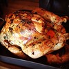
FULL DISCLOSURE: I have not made these yet, but I am going to. The good news is that Deb has determined that we have reached the pinnacle of ginger-snapness.
Anyway, in the lineup was a Cook’s Illustrated recipe for molasses spice cookies. I wanted to see how the gingersnaps I’d made would compare to them and was shocked to find the two recipes to be nearly exactly the same, ingredient for ingredient. I then turned to Google to find more gingersnap recipes and again, discovered that a whole lot of gingersnap recipes agree with one another.
In a different week, I might have fretted over this. I would feel the need to tweak them, to offer you an improvement upon the gingersnap status quo. Not this week, though. This week, it’s clear to me that if many people agree on what Gingersnap Greatness should taste like, I should feel no need to argue. I have a playground date to attend to, after all, and then maybe a nap.
I was reading Pat’s Papers this morning when I discovered this fact. Ronan Farrow started at Bard College at 11 and was then accepted to Yale’s Law School at 16, but deferred admission to work with UNICEF and Richard Holbrooke. Wikipedia explains his post-law school accolades.
In 2008, Farrow was awarded Refugees International’s McCall-Pierpaoli Humanitarian Award, for “extraordinary service to refugees and displaced people.” In 2009, he was named by New York Magazine as their “New Activist” of the year and included on their list of individuals “on the verge of changing their worlds.” In 2010, Harper’s Bazaar named him their “up-and-coming politician” of the year.
On November 19, 2011, he was named an American Rhodes Scholars-elect for 2012.
The Bears won their fifth straight game last night, but Jay Cutler, their quarterback, is down for around 6 weeks with a fractured thumb on his throwing hand. What’s crazy about it is that no one knew until after the post-game press conferences. Peter King explains how it went down:
Early in the fourth quarter of Chicago’s 31-20 win over the Chargers, Cutler threw an interception to Antoine Cason. Trying to tackle Cason near the sideline, Cutler flailed at him while being blocked, and his right hand slammed on the ground. When Cutler got up, he looked at his hand and flexed it a couple of times. But he stayed in the game and finished, throwing two more passes. After the Bears’ fifth straight win (and third straight game scoring in the thirties — the first time the Bears have done that since 2005), Cutler greeted some Chargers on the field as he normally does with foes after game. Nothing said about a sore thumb. A Bears’ PR man escorted Cutler to talk with NBC Sports’ Alex Flanagan. Nothing said about a sore thumb. Cutler showered and did his local press conference. Nothing said about a sore thumb. Coach Lovie Smith did his press conference. Nothing said about a sore thumb for Cutler.
Cutler had gotten a lot of shit about his injury during the NFC championship last year, so he probably felt the need to act a little tougher, but this is kinda crazy.
Now, I don’t think the season is dead. In fact, I think the Bears have a pretty good chance to make the playoffs. They play five bad teams and one great team. Going 3-3 puts them in good position and going 4-2 should secure them a spot. I’m probably being overly optimistic, but I think this will be a great finish to the season and the Bears will end up the top wild card spot.
Update (11/21/11): If you’d like to know more about Caleb Hanie, Cutler’s backup, National Football Post has a good summary. He had a really good preseason, which is part of the reason I’m optimistic.
By many, Di Fara is considered the holy grail of pizza. Girl Slice disagrees. Strongly.
Why is it so smoky in there? When I have visited Di Fara, there are times that my eyes have burned so much that I was crying… from pain and unhappiness, not from deliciousness. Eating at Di Fara is like eating in a coal mine.
She goes on to explain that the pizza is “…often burned, the sauce can be bland, and worst of all, it’s way too oily.”
I skew closer to holy grail than coal mine, but Girl Slice has a point — waiting over an hour for a sometimes-burnt pie with no guarantee of seating is typically not worth the effort. I’d go to Best Pizza or Totonno’s ahead of Di Fara any day.
I am not a (talented) musician, but I recognize game when I see it. At last night’s Hack and Tell, Grant Kot demoed his mobile app (iOS and Windows 7) that functions as a digital musical instrument. I bought it (99 cents on the app store) and had fun with it on the couch tonight. Of course, Grant, who’s a Julliard student, shows you what’s really possible in this video (should start 45 seconds in).
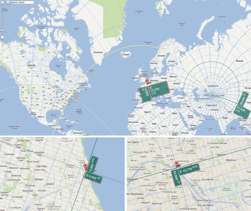
Have you ever mocked your bridge and tunnel friends about they likely live at 300th St. & 35th Ave.? Well, now you have a tool to do so. Harold Cooper created ExtendNY to show what it would be like if the NYC street grid were expanded forever by measuring the distances between streets and avenues, accounting for the curvature of the planet, and extending it across the Earth. Manhattan’s north pole resides somewhere in Uzbekistan
The Sartorialst visits Paris and now they they think they’re New Yorkers? It might be tough from 64,908th St. and 12,778th Ave. Yeah, Chicago is just like Brooklyn, except it resides at 4,443rd St. and 4,363rd Ave.
I should note, this is another great project I discovered via Hack and Tell, a meetup in NYC.
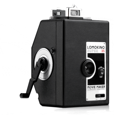
The folks behind all of the quirky, throwback still cameras have introduced their first moving picture camera. It is hand-cranked (see above) and produced a 144 frame movie from a roll of 35mm film. I would almost certainly never use this (me, not it), but I might buy it anyway because it looks beautiful. It harkens back to the Lomo LC-A, which remains one of my favorite objects.
Today, Khoi and Scott are launching a fantastic new iPad app and I want you to know about it! Mixel allows you to create and remix collages of images using your fingers and your iPad. It’s easy to do and a lot of fun, even if you just want to consume others’ work. I’ll let Khoi explain it in his own words.
But we chose collage for a very important reason: it makes art easy. Photos, the component pieces of every collage, are among the most social and viral content on the Web, and allowing people to combine them into new, highly specific expressions of who they are and what they’re interested in is powerful. Collage also has a wonderfully accessible quality; few people are comfortable with a brush or a drawing implement, but almost everyone is comfortable cutting up images and recombining them in new, expressive, surprising or hilarious ways. We all used to do this as kids.